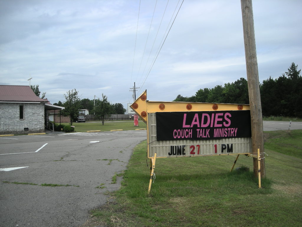
We rolled into Russellville on Thursday afternoon. Over the next few days, we took a few rides about the area visiting Mt Nebo and Dardanelle State Parks. On the way, we spotted the attached photo at a Baptist Church. I can’t explain it! And I am not sure I should! Besides that, both parks were pretty nice. After a great visit with Cynthia’s cousin, we had to bid our farewell till we (hopefully) see them later this trip on our way back west or in Las Vegas later this year. We had a relaxing 4 day weekend that included Memorial Day. Our weather was iffy most days as the storm that was behind us caught up. And did it catch up! Monday night, just in time to pull the steaks and chicken from the grill, the tornado sirens started to wail! Now, we’ve never been in an area to hear those things or experience a tornado and I must say it was disconcerting. You know, a motorcycle exposed is just about the first thing to take a hit if a tornado comes by! We were pretty fortunate though, only a really hard rain fell but hardly any wind did any blowing. Aside from the kickstand sinking in the soft driveway (like last year…), no harm done. By the time we awoke to leave on Tuesday, the weather was breaking.
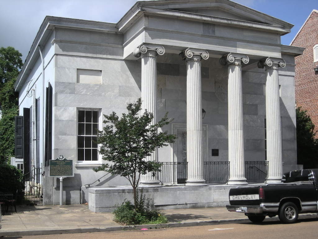
Tuesday May 26 started out pretty good. We back-tracked to Ft Smith to visit the Ft Smith National Historical Site. By the time we got there, blue skies were becoming the norm. Located pretty close to the downtown, the fort was initially built to facilitate peace between the Cherokee and Osage Indians between 1817 and 1824. By the mid-1800”s Ft Smith, though not seeing too much Civil War action, was a major supply post for the Confederates first and then the Union Army. By 1871, Ft Smith was the Federal Court to try outlaws who tried to find refuge in the Indian Territory (present day Oklahoma) and the surrounding states. Thirteen thousand cases were heard by Judge Parker and 160 were sentenced to hang. The gallows are still there! If you ever saw the Clint Eastwood movie, Hang ‘Em High, it roughly parallels the adventures of the hundreds of US Deputy Marshals that rode out from there to maintain law and order.
We then headed north to Pea Ridge National Military Park on I-49 in the upper reaches of north-west Arkansas. Known as the battle that saved Missouri for the Union, Pea Ridge saw action March 7 & 8, 1862 when an attack by Confederate forces was put down hard by a much smaller force of Federal troops. The park has a driving tour with cell phone talks at each of the 11 stops along the seven mile loop road. If you are up also around Branson or the south-west of Missouri, it is well worth a stop.
From Pea Ridge NMP we headed east towards Harrison on US 64. If you are up this way, US 64 is a great motorcycle ride. Traveling in the Ozarks, the highway passes through beautiful Eureka Springs (with LOADS of motels, all having vacancies) and many of those with signs saying either ‘Bikers Only” or some other advertisement that bikers are welcome. That’s by far the highest concentration of biker friendly territory we’ve ever been in! And no wonder, the road is a great motorcycle road. Along the way we picked up a Motorcycle Riding Guide of the Ozarks that has mapped out seven major loops from Harrison, AR. The guide even gives the mileage AND the number of turns (from a high of 662 to a low of 316)! How great is that! Complete with a map, a brief summary and written directions, we plan to be back here for sure! If you are interested in more information, try MotorcycleArkansas.com. Harrison was our jumping off point to visit Buffalo National River just south along AR 7. The park is mainly a rafting and canoeing park but we found a campsite just off AR 7 north of Jasper that was right on the river. The road in was a little tricky going in but fortunately it was short. We had a great site and with almost no one else in the campground.
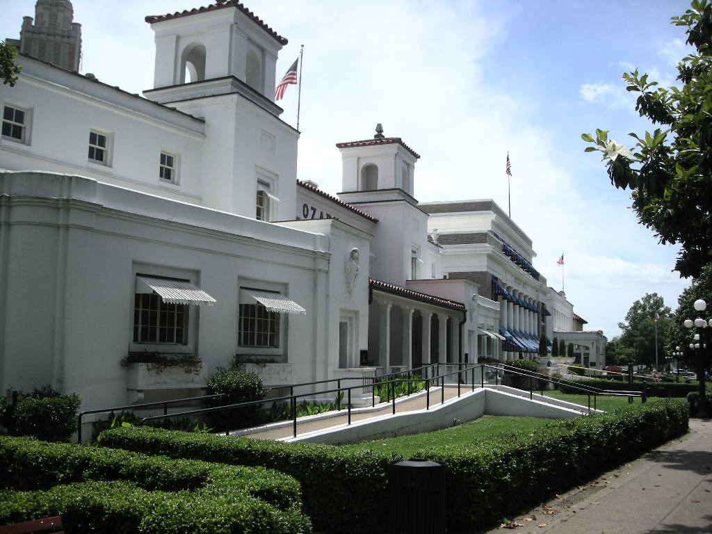
Up early Wednesday, May 27 to the sound of the most irritating bird we have ever heard. So much so the guys camped next to us got up and out to chase it away! Back up the steep gravel road we were soon headed south again with our sights on Hot Springs National Park. We stayed on AR 7 the whole way, pretty much cutting Arkansas in half from north to south. Almost the entire route is dotted in our Rand McNally, and rightfully so. The hot springs at Hot Springs have been around a long time. There is documentation that Native Americans visited as early as the 1700’s. Since then, a whole town has grown up there! The water is not heated by volcanic action but rather from the shear depth that it travels, gaining 4 degrees every 300 feet down. The water flowing from the springs today (there are many) is 4,000 years old! Once catering to mobsters, the bath houses on what is now known as Bath House Row National Historical Landmark still ply the trade as well as serve as the National Park Visitors Center and a museum. The town is worth a visit. It is called, “America’s Spa”. There is also a loop road to the top of the mountain that backs to Hot Springs and affords great views. We camped at the park campground even though the sites were a little close together but ours backed to a pretty big stream and that put us asleep immediately! Besides, at $10.00, we thought it a bargain for a national park!
We continued on AR 7 to El Dorado, AR and then south to cross the Mississippi into familiar territory at Natchez, MS. We headed straight to Natchez State Park up US 61 where we stayed last year. It is a great park with nice sites. We stopped for our lunch at the Felsenthal National Wildlife Refuge visitor’s center and spent time looking over the exhibits of the abundant wildlife that is in that area. Along the way we rounded turns only to find the road completely flooded (which gave pause I assure you!) and what seemed like a stream to ford under the railroad bridge. Not one to turn back, we pressed on albeit slowly. All around the Ouachita River basin was flooded from the recent rains. All in all though AR 7 is a great road. The day was hot and we were glad to get in the shade of the campsite even though the humidity remained pretty high.
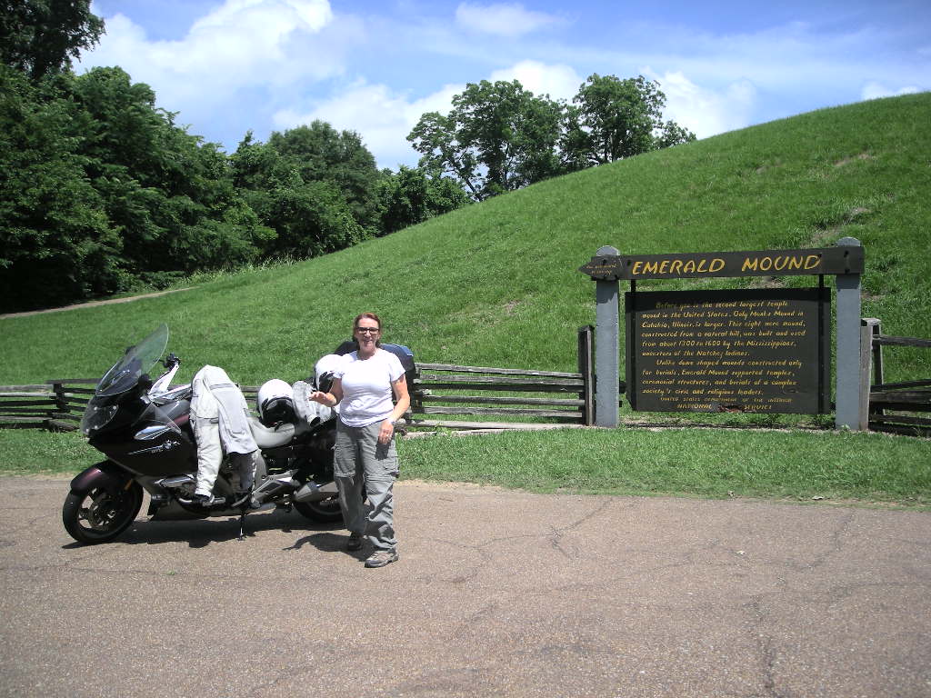
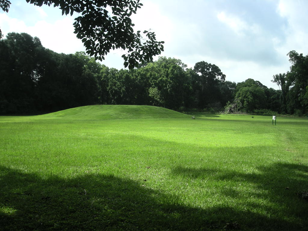
We planned to stay in Natchez two days since there are SO many places we did not visit last trip. We have about 15 National Historic Landmarks to see, a lot of them the antebellum homes in and around the city. Well, we did not get to the 15! I guess we got ‘housed out’! Besides they all tend to start looking the same. We did however get to two other interesting places. The first was the Grand Village of the Natchez Indians. Just outside of town, the area was once the village for the Natchez Indians and was chronicled by early French explorers. Complete with three mounds, the museum has many artifacts from the excavations that took place in the early 1900’s. Our next stop was close to our camp, just off the Natchez Trace Parkway. Emerald Mound was built and used from about the 1200’s and 1700’s. The mound is huge! Thirty five feet high and it covers 8 acres! Pretty cool area and it is all open for you to hike on and explore. It is a wonder how the Indians built up such a high mound with no modern tools or machines.
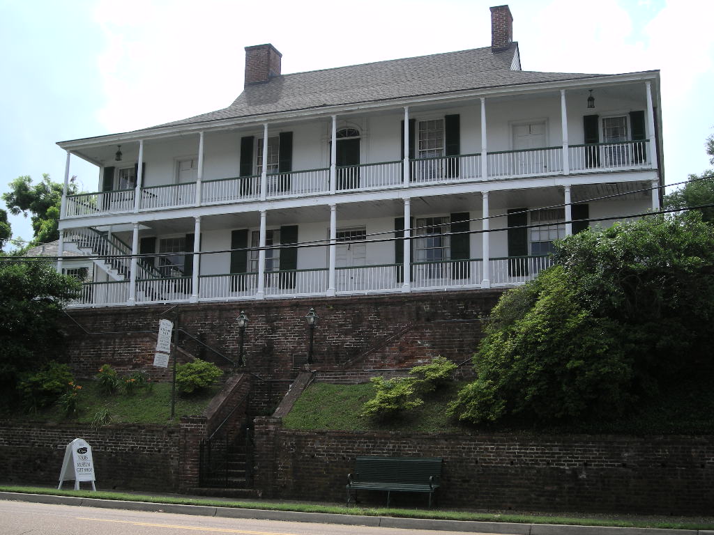
We had a few showers in Natchez since it was so humid but on Saturday, May 30, we had a great morning. We packed early and hit US 61 (The Great River Road) south towards Baton Rouge, LA. Along the way, we wanted to stop at Port Hudson National Historical Landmark in Port Hudson, LA. This was the site of the longest siege in US military history. Controlled by the Confederates, the fort at Port Hudson commanded a stretch of the Mississippi River. The siege began on May 23 1863 after Union troops marched from Baton Rouge to take the fort and help open up the Mississippi from Port Hudson to Vicksburg. Forty-eight days later, the Confederates surrendered. Though the Mississippi River no longer takes its course close to the fort as in 1863, the grounds and especially the museum are well worth the stop. They had one of the best displays of any Civil War site we’ve been to. Pretty amazing for being such a relatively unknown place. From there we decided to visit Oak Alley Plantation, it too being a National Historical Landmark and one of the very best antebellum homes that used to line the lower Mississippi River in the early to mid-1800’s. We crossed the river just north of New Orleans and along LA 18 is where you will find Oak Alley (you can’t miss it!). Built by French settlers in the early 1800’s (before the Louisiana Purchase) as a sugar plantation (which the remaining property still is), Oak Alley is a must see if you only get to see one plantation home. The 300 year old oaks are worth the visit by themselves!
It was getting late and we wanted to make a campground before it got too late (meaning they would be full), we blasted down I-10 towards New Orleans and just missed a big thunderstorm by cutting off on I-610 towards Slidell. We found a great spot near Ocean Springs called Shepard State Park in Mississippi.
Continuing east, we took off early Sunday to try to burn up as many of the 850 miles left to get to Marathon Key, 50 miles from Key West. It was all about the miles. We made reservations for a hotel in Marathon (thanks for the tip Gary!) and needed to do the 850 in three days. It all revolves around getting out to see the Dry Tortugas National Park off the coast. After a grueling 420 miles from Shepard to Gainesville, FL, we opted for a hotel room since the day was filled with rain and when not raining, hot as hell! It just wore us out. Now we have an easy two days and 400 miles to go. That’s much better for sightseeing!
We ended May with a total of 12,477 miles thus far with eight states (17 more to go) and 51 parks (one more than needed) on our 2015 National Parks Tour. Stay tuned, much more to come! Greg & Cynthia