Monday, July 14 started off good with a quick trip to the Verizon store in Rapid City to get a new phone. Fortunately, they had a Blackberry that was cheap but like most things electronic, if you had them a while, it’s a new learning curve for you. Anyway, we were out of the store by 11:00 and we headed back towards SD 79 south and proceeded on that well maintained four lane till we got just into Nebraska. Once in Nebraska, we turned right on US 20 for an easy 50 miles. Out there in the western part of Nebraska, as probably is the case in other remote areas, you have to wonder what people do that live in these little towns like Crawford, Harrison and Whitney, Nebraska. I didn’t see too much going on. You drive for hours and don’t encounter too many other cars either. We turned south at NE 29 for our first stop at Agate Fossil Beds National Monument.
Agate Fossil Beds National Monument is in a pretty remote area of Nebraska, north of Scottsbluff. It is believed that about 19-20 million years ago that area was struck by a drought that deprived many early mammals of water and consequently they perished an mass. The resulting ‘bonebed’ of hundreds of skeletons were preserved under layers of silt, volcanic ash and fine sand. So extensive were the finds at this area that bones from this park are exhibited in museums throughout the world. Pretty cool! The exhibit in the visitor’s center has some pretty awesome creatures that convince pretty quickly that you wouldn’t have wanted to live back then! There is a lot more to discover about Agate Fossil Beds that we hope you can uncover by visiting yourself.
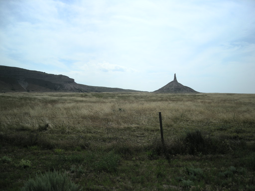
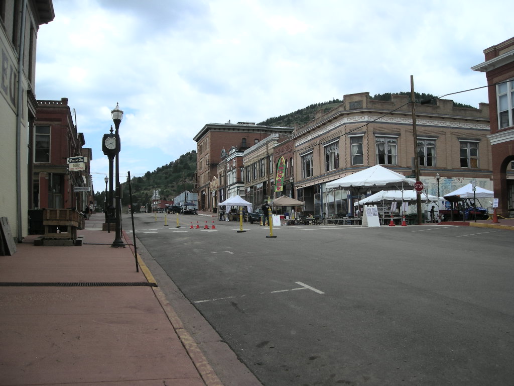
We left Agate Fossil Beds with lots of time to spare so we planned to see Scotts Bluff National Monument and Chimney Rock National Historical Site before turning in to the Hampton Inn in Scottsbluff. So once in town, we checked in and then continued on to Chimney Rock via NE 92. It was a pretty nice drive right up till we ran into a ‘road closed’ sign a mere ¼ mile from the park entrance. We could see the entrance across the railroad tracks but just couldn’t reach them! I knew the distance to go all the way around to US 26 was prohibitive since it was getting late. I noticed on the way down the road that a car and a motorcycle took a dirt road off the main road we had been travelling and since they had Nebraska license plates, I figured they knew something. We headed back to that dirt road and lo and behold, the sign said that it was the “Old Oregon Trail Road” so we figured we couldn’t go too far wrong! The road wasn’t bad and the GPS picked up on the change and had us do a left on another dirt road and before we knew it, we were at the entrance to Chimney Rock.
Chimney Rock was an essential landmark for folks travelling the Oregon Trail (and California and Mormon Trails which are essentially the same along this stretch). It is said that those travelers were quite excited to see a land feature after spending more than a month walking the featureless plains from their starting points. Aside from the North Platte River, which the Trail parallels, it served as a guidepost for those on the trail. I must admit, I was pretty excited to have driven on the REAL Oregon Trail. Little did I know, we would be doing that again at Scottsbluff! Chimney Rock was designated a National Historic Site in 1956 and is operated by the Nebraska Historical Society. The National Parks Pass does get you a discount on admission though. There is a really good film that covers a lot of aspects of travel on the Oregon Trail and we found all of it to be pretty interesting. We left Chimney Rock and called it a day in Scottsbluff.
On Tuesday, July 15 before heading out, I needed to determine were we would be in about 1,000 more miles since the 18,000 mile service would be due on the K1600. I figured we try to get an appointment in Denver so when I tried to us my Jetpack (the mobile internet device I brought with me) but I saw that it quit working. Bummer! A quick flip through the phone book, and I found a Verizon store in Scottsbluff. I don’t know why tried the internet to find a BMW dealer, I guess I needed to find out it went south and besides, I brought the BMWMOA Anonymous book with me that I used two or three times prior to find dealers on this trip. Anyway, in the meantime, we headed out to Scotts Bluff National Monument while we waited for Verizon to open.
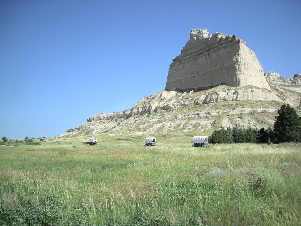
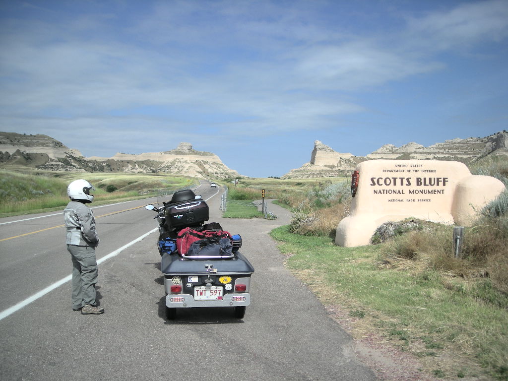
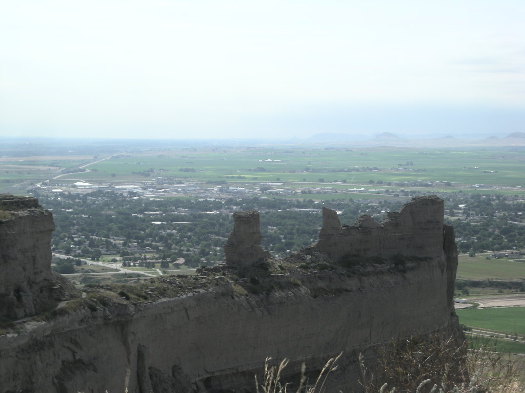
Scotts Bluff National Monument is a very cool place to visit. Just standing there between the cliffs at the visitor’s center and imagining that between 350,000 and 500,000 people passed through this small opening in the cliffs during the Oregon Trail’s heyday is stirring. The reason they all went through this pass is because the land to the north between it and the North Platte River was badland at that time. Everyone had to pass Scotts Bluff. This was the really cool part of the trip- driving the bike towards Scotts Bluff out US 26 which is in the exact place the Oregon Trail was. It was then I had an epiphany! Next year’s trip could be the re-trace of all these important trails used in the 1800’s and the trace of Lewis and Clark’s trip thrown in for good measure! But I digress… Scotts Bluff is about 500 feet tall and is a record of the Great American Desert’s past. By examining Eagle Rock’s 10 million year history, geologists have determined the various materials that made up the early desert (plains). It is more than a landmark! There is a park road that you can drive that takes you up into the bluffs and passes through two tunnels. The views from the top are tremendous! You can see Chimney Rock 25 or so miles distant and those wagons coming from miles away!
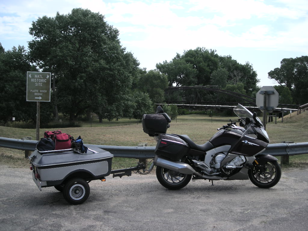
After that moving experience, we stopped at Verizon before blowing out of town. Seems they had to order my replacement- none were in stock. Fortunately, I got a service appointment at BMW of Denver for Thursday while we were at the National Monument and we found a Verizon store not far away. Drew was good enough to have it overnighted to that store so we’ll get it when we are in Aurora, Colorado. We continued on US 26 (the REAL Oregon Trail) west towards our next visit at Fort Laramie National Historical Site. On the way there, we stopped at the Platte River Bridge National Landmark just outside the fort. The bridge was built to make access to the fort easier and eliminated the ferry system that was in place. It was a cool old iron bridge you can walk over but not drive.
Fort Laramie has a long history. He original ‘fort’ was built in 1841 and was called Fort William. It served as a trading post until it was replaced by a larger fort named Fort John. What was interesting to us was that the early trappers in this area were all French. Then it dawned on us that this was all part of the Louisiana Purchase and was explored by the French early in the 1800’s. In 1849 the U.S. bought Fort John to establish a presence along the emigrant trails and renamed it Fort Laramie. The fort became the principal military outpost, transportation and communication hub in the Northern Plains and hosted several treaty negotiations with Northern Plains Indian Nations. The buildings and grounds are extensive and there is a lot to see and do at the site. Riding into and out of the fort on the GTL made it easy to imagine those soldiers riding in and out in the columns we see today in the old westerns. Guess this is as close to it as we’ll get!
We ended our ride on US 26 and the Oregon Trail by taking the onramp to I-25 south. So much for the nostalgia! We immediately saw on the southern horizon some clouds building and as we got closer, we were sure we’d be dumped on. We were riding south along the eastern edge of the Front Range and we were in the cool air. It never got over 75 degrees. Off to our left in the mountains, the clouds were heavy and the temps, I am sure, were much higher. We stopped ever so briefly for gas in Cheyenne, WY and made tracks for Ft Collins, CO. The rain came upon us fast and to make matters worse, we could not find a hotel. All of them were sold out! We travelled on and got lucky at the US 34 exit- the direct route to Rocky Mountain National Park. In the evening it continued to pour and we went to bed hoping for a better day.
Wednesday, July 16 was pretty cloudy but there were some sunny breaks. The forecast wasn’t good though. Heavy storms for the afternoon. The best way to ensure it won’t rain is to put on your rain gear. So that is what we did. Turns out, we didn’t need it! We headed west out US 34 towards Estes Park and the gateway to Rocky Mountain National Park. The drive is great! The road follows the Big Thompson River and it is beautiful up through the canyon. You could see the aftermath of the devastating flood the area had a year or so ago. All’s getting back on track though. We got to Estes Park, CO and the sun was still shining. We checked into the visitor’s center at Beaver Meadows to get our stamp. We didn’t have any intention to tour the park since we were just there last year on our way back from Newfoundland. So off we went but this time heading back to Denver, we took CO 7 towards Boulder. Be SURE to travel CO 7 if you are heading to Rocky Mountain from the south. Take US 34 from I-25 and that leads right to CO 7. It is a GREAT motorcycling road! Once back in Denver, we checked at the Verizon store and the Jetpack wasn’t in but was promised to be delivered by Fedex by 3:00 pm. We didn’t wait. We took off south for our hotel in Castle Rock. Lots of storms in the area again that night but clearing expected for Thursday.
Thursday, July 17 was a cloudy morning with just a little drizzle. We left early from the hotel because I figured traffic would be pretty bad on the way to BMW of Denver in Aurora. It turned out not to be too bad and we were there in 45 minutes. The drizzle let up fast but that brought the humidity. We checked in to the dealer and reviewed the work to be done. I decided to get them to install the brake light that mounts in the travel trunk since it is up high and I had noticed that with a bag strapped to the top of the trailer, it was hard to see the brake light. Best be safe. We were there early so we took a walk to a restaurant that was close and had a coffee. Back at the dealer by about 10:30, it began our long wait for the bike. So, while we waited, we watched some TV, fooled around on the internet, bought a new pair of gloves, watched some TV, roamed around the dealership, watched some TV and then some more TV. The folks in service let me know the rear brakes were at 25% so we had them replace those too. At 4:30 they came and got us AND they washed the bike! All those bugs and dirt- gone! I was a little disappointed since I had been collecting them for so long.... It was really long day there but the work had to be done. Since we had been there so long, the dealership’s general manager came out and gave us two (nice) tee shirts for being such good sports! Those were on top of the two the parts guy gave us! All the folks at BMW of Denver were great! I highly recommend them for any service or accessory need you might have if you are in the area. We left there and scooted up I-225 to Verizon and after a really fun time in the store (no really, the folks were great!) we got our Jetpack straightened out and we headed south on I-25 to get as far as we could. Since the daylight was fading, we opted to stay in a hotel once again in Colorado Springs.
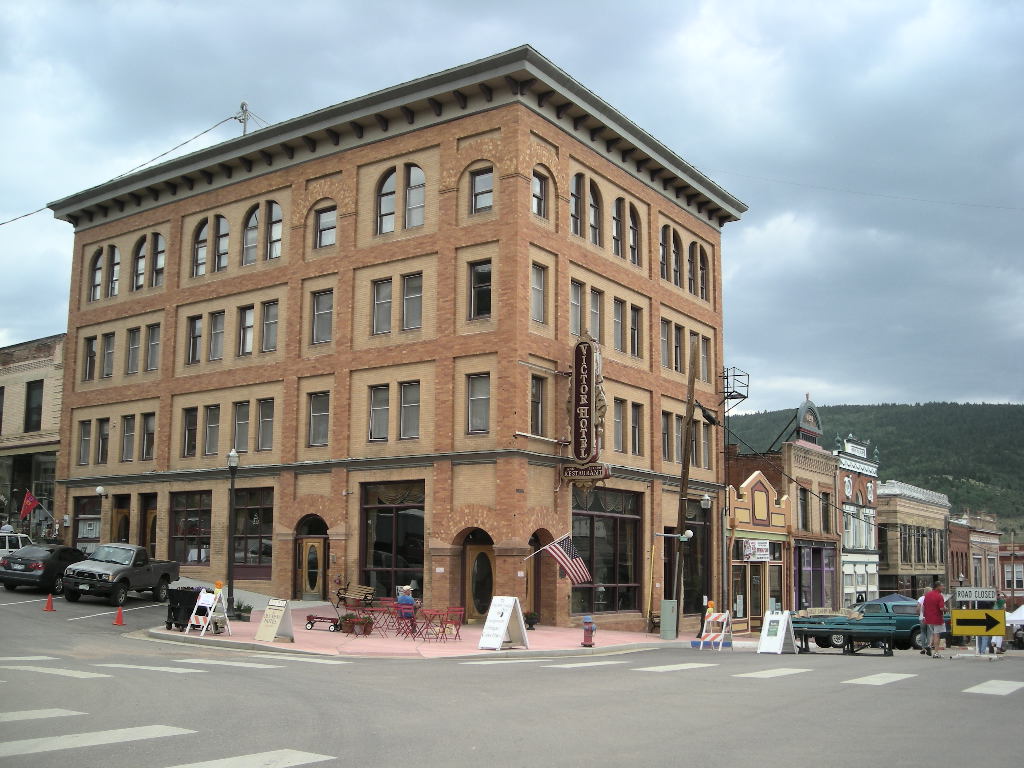
It was a good night to get some writing done and log all the expenses I had been saving. We kicked off the day (7-18) to bright sunshine and headed to our first stop at Florissant Fossil Beds National Monument just west of Colorado Springs and Pike’s Peak. I thought about doing Pike’s Peak but decided against it since I had been there and Cynthia wasn’t really excited about going that distance. It is a great view form up there but we seem to have to keep reminding ourselves that we are doing the national Parks Tour, not just sightseeing around the country. We took US 24 out of Colorado Springs and before we knew it, we were at our destination. Florissant Fossil Beds is a national monument that encompasses a huge area that was once covered in giant Sequoia trees millions of years ago when the area was cooler and wetter than today. The fossilized stumps of these giants can be seen from the Petrified Forest Loop Trail. It is pretty cool to know that just under your feet and throughout the park lie hundreds more of the petrified stumps. In addition to those, the park hosts a spectacular collection of fossilized bugs and plants that are on display. So much diversity in fossils has been found that fossils from Florissant are in over 20 museums in both the U.S. and Great Britain. This was a very cool spot! Since we had lots of time and that Cripple Creek was just 18 miles distant, we took CO 67 south and toured the Cripple Creek area. I was a little disappointed in Cripple Creek. I had been there MANY years ago when it was pretty close to a ghost town. Today, it is almost nothing but casinos. We didn’t stay long. We continued on to Victor to see if it had changed as much. In Victor, it was a lot better. The town is reviving since there is a huge open pit gold mine between it and Cripple Creek. It wasn’t much to look as you pass it and you can’t see it from either town, which is good. Victor was having its Gold Rush Days and was setting everything up. We passed in and out of a lot of the stores and even got an impromptu round-up of the town’s ghosts from a shopkeeper! It’s nice when that sort of thing happens. We headed to our campsite but before we got there, we got pounded by a quick hail and rain storm just as we sought refuge at Florissant Fossil Beds. We ended up getting pretty wet. Just like it is in the West in the summer, the storm passed fast and we were pretty much dry by the time we got to camp. We ended our day at Eleven Mile Lake State Park just a little further west on US 24.
For July 19, we planned to ride south again and end up at Great Sand Dunes but we got a little side-tracked. We made a brief stop in Pueblo and then a stop at a rest area just north of Walsenburg. There a fellow on a Ducati told us to take CO 12 from Walsenburg down to Trinidad; it’s called the Road of Legends. How bad could a road called that be? Against better judgment (meaning we are on a national parks quest, not out to ride every cool road), we decided to give the road a chance since it actually brought us closer to another national monument- Capulin Volcano. Anyway, once we rode the road, both Cynthia and I couldn’t figure out why it was called that. Don’t get me wrong, it was nice but legendary, maybe not. We had to cross over into New Mexico to find a camp site since it was still the weekend and found a nice one at Sugarite State Park, just east of Raton. At $10 a night, what’s not to like!? The camp hosts were great and we chatted with them the longest while. It was a long day, mostly because we were on back roads where you can’t really make any time, that is pulling a trailer.
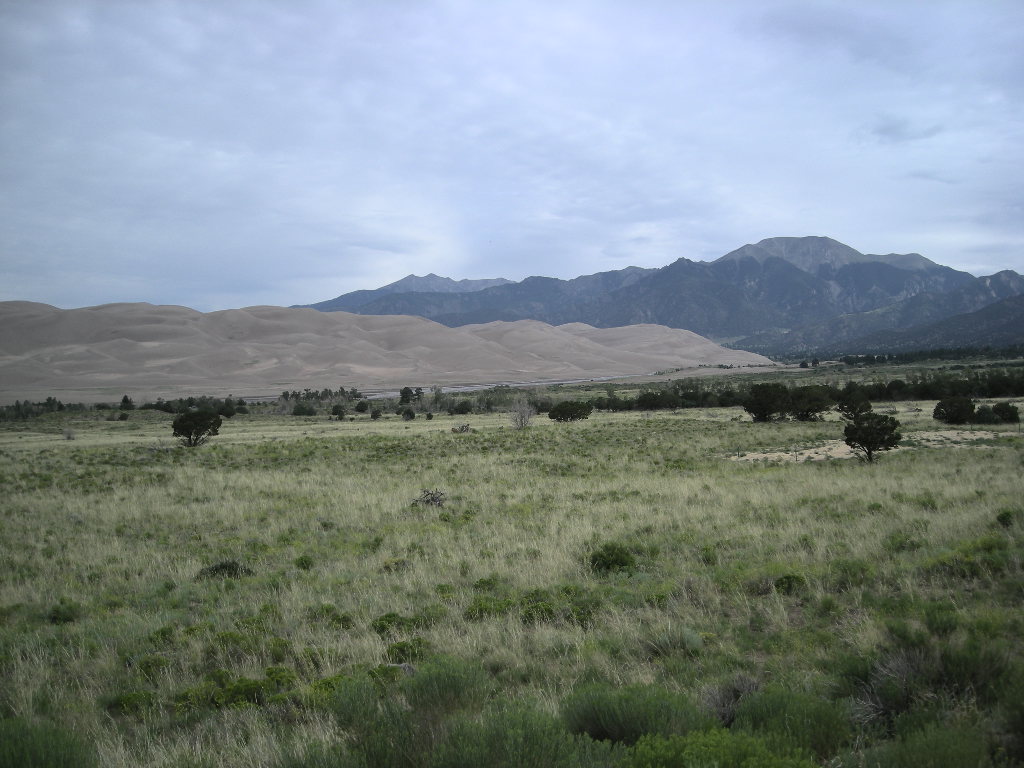
It was a beautiful New Mexico morning on Sunday and we headed out to Capulin via NM 72. This was a wonderful drive in the high country with hour-long views of the numerous volcanoes that dot this part of New Mexico to the south and the plains of southern Colorado to the north. Within 75 miles, we pulled into Capulin Volcano National Monument. We were here last September when we went to the Sipapu Rally so we didn’t do much. Capulin is one of the best examples of a cone volcano. You can take the drive to the top and hike into the crater if you like. Since we had done this, we were pretty much stamp collecting only. Capulin is a relatively recent volcano, having last erupted about 60,000 years ago (about the same time as those outside Flagstaff, AZ). It had four distinct flows and they can be seen from the top. It is a pretty interesting place and worth the stop. Not many places you can drive to the top of a volcano and hike into it! After a gas stop and grocery store visit in Raton, we took the fairly familiar US 64 west to Eagle Nest and then north on NM 38 to NM 522 north. Both these roads are great and the Eagle Nest region of New Mexico is beautiful! NM 522 took us straight up to Fort Garland, CO and our stop for the day at Great Sand Dunes National Park and Preserve where we camped for the night.
Great Sand Dunes National Park and Preserve house the tallest sand dunes in North America at about 750 feet. This area is one of the only places on earth that encompasses alpine forest, desert sand dunes and wetlands all in one place! Nestled against the Sangre de Cristo (Blood of Christ) Mountains, the Great Sand Dunes also represent 11% of a 330 square mile deposit of sand. It is pretty impressive as well as beautiful set against the green alpine region of the mountains. You can surf the sand, hike the many trails or blaze one of your own. Best time to hike is early or late because the sand temperature can reach an impressive (on your feet) 140 degrees. Current research places the dunes at about 440,000 years old and was formed by the prevailing southwest winds blowing the sand off the plains and towards the mountains where they are met by storm winds from the northeast. So the sands all got deposited in this one area. Our campsite was good with a view of the dunes and although we had a wet night, all was dry by the morning and quite warm!
On Monday, our plan was to make it to Mesa Verde but it didn’t work out. We got a late start from Great Sand Dunes and really took our time going across Colorado on US 160. Most of the trip was through valleys that were quite nice with speeds around 65 as to not get too boring. Once past Del Norte, CO, things got a lot more interesting! The road began its path through the Rockies and in typical fashion, challenges your riding skills! Once we were over the Wolf Pass at 10,856 feet things settled a bit to sweeping turns and lower elevations to our next stop at Chimney Rock National Monument. You may remember a Chimney Rock in Nebraska too. That one was a national historic site. This one is a national monument and is located in the Ute Reservation. Its looks a lot like the Nebraska one but at this site, there are cliff dwellings and other Native American archeological sites. There was a charge to drive the all gravel road to the best areas and we elected to not do that pulling a trailer. Even one of the guides suggested we by-pass the tour since a lot of the gravel road almost requires a four wheel drive vehicle. We did spend some time picnicking since it was pretty hot by then and made the decision to only go to Durango, CO for the day and hit Mesa Verde in the morning, about 50 miles further west. So that’s what we did. Along the way I saw a Forest Service sign for Lange Canyon but I was going a bit too fast to stop and take a photo! Once in Durango, we took time to write, organize and clean things up a bit (including us!).
There are more great parks in store so stay tuned, we’ll be back soon with our next installment of our National Parks Tour! Greg & Cynthia.