
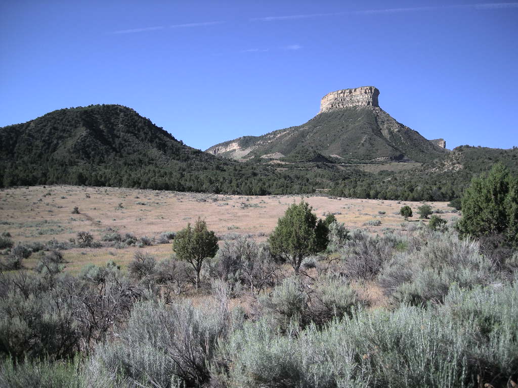
It was another great morning! Sun was shining and the temps were pretty warm. We got started early in the hopes of getting a camping spot at Mesa Verde before they filled up. We’ve noticed that, especially at the more popular parks, the campgrounds are either too small and fill quickly or there are a lot of folks travelling too! We got to Mesa Verde at about 10:00 am and lots of folks were leaving. The receptionist and the campground registration was helpful in pointing us to the campsites that were the shadiest. We set up camp and headed straight out to the Anasazi Heritage Center which is also the headquarters for the canyons of the Ancients National Monument. It was an easy drive into Cortez and then north on CO 145. All told, about 40 miles. But by now, the sun was getting pretty hot. The visitor’s center for the Anasazi Heritage Center is really nice. The associated national monument, Canyons of the Ancients was established by Bill Clinton and the center was built soon after. This is a primo visitor’s center. Two great films run at request and the museum has over 1.5 million artifacts from the immediate area. Most folks think the Puebloans were mainly in the cliff dwellings like Mesa Verde but scientists have discovered that thousands more lived in what is now called the Great Sage Plain, which encompasses the lowlands in the Four Corners region. We didn’t know that. The visitor’s center is time well spent and we highly recommend starting the area tour there.
Once we saw the exhibits and had a little picnic on the grounds, we headed out CO 184 to hook up with US 491 to gain access to the broader Canyons of the Ancients. That’s when the temperature really started to climb. This national monument is HUGE! Accessible mostly as backcountry driving or hiking, the purpose of establishing it was to protest the Native American historical sites that are so abundant in the area. Taking county Road CC from US 491, you head straight into the monument and our first stop, within the monument was Hovenweep National Monument. Hovenweep is actually in Colorado and Utah. Straddling both states, Hovenweep is a collection of 5 Pueblos stretching many miles apart but all (except one, the largest) located at the head of canyons where springs are typically found. Abandoned around 1200 for some unknown reason, these sites are mainly ruins but enough of the structures remain to amaze when you see them.
We bugged out of there and continued on to County Road G to complete our loop through the Canyons of the Ancients NM. As we were headed towards Cortez again, the temperature rose to a sweltering 103. When it is that hot, the breeze is even unpleasant. Despite that, County Road G is a really nice motorcycle road. Just be careful of the ‘farm vehicles’ going slow and the occasional bear like the one we saw. Who would have thought bears out there?! It was hot, looked like desert (mostly) except along the river for about 1000 yards on either side. We talked to a local who told us bears are VERY common around Cortez. I never would have guessed that! Our round trip was about 150 miles but you see a lot!
We were back at Mesa Verde just in time to bake in the sun at our camp. It was time for action. We surveyed the camp ground and fortunately two sites down was vacant and had some pretty good shade on the picnic table and the tent site. About 15 minutes later, we were in our new digs! We had intended to tour the complete Mesa Verde National Park but there just wasn’t enough time. What happened was that I had noticed the front tire was getting close to the wear bars so I called Grand Junction BMW to book an appointment for Thursday. That made it such that we needed to leave on Wednesday for a stop at Black Canyon of the Gunnison National Park. Anyway, that tire lasted a little better than 12,000 miles, almost 2,000 miles less than the Pilot Road 3 that it replaced. I am thinking the less mileage was due to the heat that the Pilot Road 4 has had to endure. Our planning now is centered on Las Vegas at the end of the month for a brief visit so maybe we’ll stay in the general Four Corners area and visit Mesa Verde again. In the meantime, the long and short of Mesa Verde is an interesting story.
At about AD 550, some of the people living in the Four Corners region decided to move onto the Mesa Verde. They flourished there for over 700 years, building multiple structures all along the mesa and parallel Wetherill Mesa. Mesa Verde is probably one of the most studied Pueblo Cliff dwelling sites in the country. Interestingly, these people actually started out building ‘pit houses’. Soon as they prospered, they began building above ground homes fashioned from mud and poles. After that, they built their homes out of stones. These are the structures typically seen at Mesa Verde today. It is estimated that at the height of the civilization there, thousands of people occupied Mesa Verde. Pretty hard to imagine! If you plan to visit, there are two great park roads (as most park roads are!) that wind through the park. Both are dead-ends so you have to backtrack your way out the way you went in. The views are pretty spectacular that we saw. To visit the cliff dwellings, you’ll need a tour ticket for a ranger led tour. No trailers are allowed past the campground and a trailer drop zone is provided at the entrance to the park if you aren’t camping. Tickets for the tours are available at the visitor’s center.
Wednesday, July 23 had us taking it a little slower in the morning since we were awakened the night before by some pretty monstrous winds. Besides, we knew we weren’t going far. We got on the road about 9:00 and it was 83 degrees already! Our plan was to continue up CO 145 towards Telluride and then head east on CO 62 to hookup with US 550 north to Montrose and on into Black Canyon just east on US 50. We have to tell you, drive CO 145 from Cortez to at least Telluride! It is a BEAUTIFUL road! The temps were cooler and the road was smooth with nice sweepers. Pay attention for animals though. The road basically follows Dolores Creek north. By the time we got to Telluride, the mountains were soaring! This part of Colorado is wonderful! We made a quick stop in Telluride but elected not to stay since there were SO many people there. The town itself is well cared for and reflects its mining days it a very upscale way. I suspect property is right expensive there! We continued on up CO 145 to CO 62 and on up US 550 to Montrose. The US 550 leg wasn’t that great. Our experience from last year was that US 550 south from Montrose through Silverton to Durango IS a must drive (the Million Dollar Highway).
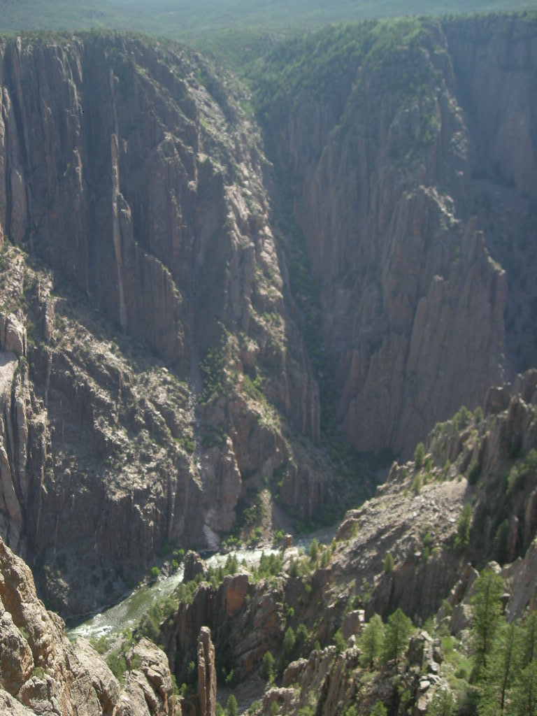
We arrived in the Black Canyon of the Gunnison National Park in plenty of time to get a good site and spend time writing even after a grocery store run on the way. Black Canyon is so named because the canyon is so deep, so sheer and narrow that very little sunlight penetrates it. The canyon has been a barrier to humans for a very long time. The only evidence of human habitation is along the rim, never in the gorge, not even by the Ute Indians. Interestingly, the Gunnison River, in the 48 miles of the canyon, loses more elevation than the entire 1,500 miles of the Mississippi’s length. Black Canyon of the Gunnison is really worth a visit. Two campgrounds are in the park, both north and south but are separated by about 2-3 hours of driving. There are numerous overlooks as you might expect at a canyon and a few trails. If you are in the area, stop by. It’s a nice park.
We got a little rain late in the day yesterday and in the morning; just enough to make it interesting and we had a quiet afternoon watching the deer roam all around us eating, seemingly not to care about us at all! Today (Thursday, July 24) started out great and with only about 100 miles to Grand Junction BMW, we had it made! After a stop at the visitor’s center and a hike down to Gunnison Point to look up and down the canyon, we were off. I noticed that my GPS wasn’t working too good. It kept saying that it was losing the power source. I figured I would take care of that once at BMW of Grand Junction. We headed out US 50 from Montrose to Grand Junction and were there pretty quick. US 50 isn’t that interesting out that way but it is on the west side of the Rockies. We were pretty early getting to our 2:00 pm appointment so we stopped at Walmart to re-supply. The dealership at Grand Junction is actually a Harley dealer that picked up BMW and KTM. A browse around the Harley side gave me a new appreciation for the marketing they do! Every imaginable thing has the Harley brand on it. From cups to baby clothes to underwear, you name it, you can (and I am sure they do) go all out Harley-Davidson. It’s a little strange to us. The showroom for BMW and KTM (they are displayed together) is a room about 20x50. Not much. I was a little apprehensive. The guys there were great though even though they washed off the bug collection I had. They took the 1600 in at 2:00 and by 3:30 we had the oil change and new tire. The Holiday Inn right next door was so convenient; we decided to stay there instead of driving out to find a campsite with the GPS on the fritz.
It was a good start to Friday, July 25 but quickly went downhill for a few hours. Without the GPS working, its hard to find places in a strange town. It is about the only time I use the GPS. Anyway, we got a great tour of Grand Junction before we accomplished mailing my Nevada tag back and getting a new cable for the GPS. Seems the issue was that little plug that fits into the back of the Garman doesn’t really like to be exposed to the elements for long! It failed, maybe from corrosion. The new one worked out great. It wasn’t until about noon did we finally make the trek up to Colorado National Monument. These canyons are easily seen from Grand Junction but the best is the 30 or so miles of park road once you are in the monument. Colorado National Monument preserves one of the grand landscapes of the American west. The canyons are big and the colors are fantastic! If you have been to southern Utah, then you know the colors. We had a great ride through the park starting on the east end in Grand Junction and ending in Fruita, CO, about 30 miles from Utah. We stopped at a few overlooks and had our customary picnic once down off the plateau at the Colorado visitor’s center. The weather was great, not too hot with temps around 90 and the cloud cover protecting us from the sun (and higher temps!). We jumped onto I-70 and headed west towards Arches National Park.
If you get out this way, be SURE to drive UT 128 from either Moab to Interstate 70 or visa-versa. It is a BEAUTIFUL road! Following the Colorado River 90% of the way, it winds through canyons and hugs the river for a pretty nice “hard to keep your eyes on the road’ road. But you’d better! Not many guard rails…. As we travelled along, we could see rafters in the river floating down stream and seemingly having a ball! It looked very refreshing to us as we were enduring the temperature climbing into the 100’s. There are plenty of campsites along the river and we dove into one only to find out that there wasn’t any water available, but we would have to drive about 40 miles round trip to have. We decided against that even though we REALLY wanted out of the sun right then. We pressed on down UT 128 and ended in Moab. We swung north on US 191 and stopped in Arches National Park. Even though the campground was full, we spent a little time in the visitor’s center learning a little more about the park than we had last year when we visited.
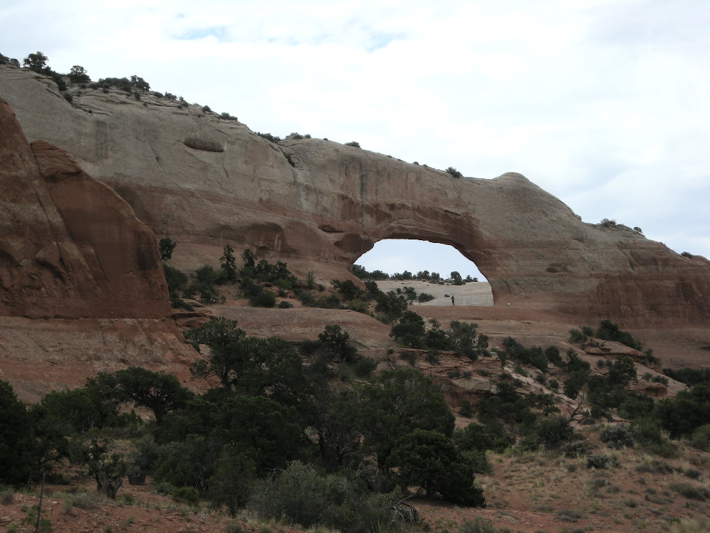
Arches National Park is wonderful collection of natural arches carved by wind and rain. Over 100 million years of erosion has created one of the world’s greatest densities of natural arches. It is an amazing place and the colors are truly spectacular! There are over 2,000 documented arches, from three feet (the minimum to be considered an arch) to the longest, Landscape Arch measuring 306 feet from base to base. It is incredible what nature does! The park road is one way in and one way out so traffic can be a little trying as can be the turn-outs to take longer views of the overlooks and arches. Take your time! Besides being invisible on a motorcycle, people aren’t looking at much other than the scenery! The park also boasts 15 trails in various lengths and difficulties, so finding your way into the backcountry to see some of the more spectacular arches is easy…but not when it is over 100 degrees and no shade! Utah is hard to beat for spectacular scenery and this whole area of southeastern Utah is premier. Since we couldn’t get a campsite, we rode up to the BLM (Bureau of Land Management) campground we had been to last year at Horsethief. Almost no one was there. No wonder! Little shade and it was HOT! Another lucky twist for us was that we got the same campsite as before and that one did offer shade but we had to wait for the shade to encompass the picnic table. It was a good night albeit a warm one!
We planned to make it a short day on Saturday, July 26 and only go as far as Natural Bridges National Monument, about 150 miles from our camp. It was 83 degrees at 8:00 am so we opted to stop at the Canyonlands National Park visitor’s center briefly (since we had been here last year too) and go straight south out of Moab on US 191 towards Blanding, UT. Canyonlands is split by the Green and Colorado Rivers into three distinct regions: the Island in the Sky (the easiest to get to); The Maze and The Needles. Each has its own ‘personality’. Mostly a backcountry park, having a GS would have been wonderful! After Canyonlands, we stopped for another coffee and to check our voice messages and email before leaving town. We found out that we didn’t need to be back in Vegas till August 5 so we whipped out the Rand-McNally and started planning! We decided to stick to our original plan of touring southeastern Utah and only go as far south as Capitol Reef National Park since we have the stamp from Bryce and Zion. From there we will head to Great Basin National Park in Nevada then north again into Idaho probably. I guess we ALL will have to wait and see! That we plan no more than 4 days ahead is our rule so who knows? Well, to get back on track- we had a great ride down US 191. The temps dropped right into the low 80’s and it was delightful! We stopped briefly at Wilson Arch (right on US 191) and again in Blanding for gas (be sure to do so, Hanksville is 122 miles away and NO services on UT 95 till then). Turning left at UT 95, we were at our destination for the day, Natural Bridges National Monument.
Natural Bridges National Monument really is out in nowhere. I was glad we remembered they have a campground because it is a long way to one out in those parts! We checked in around 1:00 pm and by about 3:30 pm, the campground was full. We got a lovely spot with shade (after pulling the table around quite a bit) all afternoon for the picnic table and we were both able to catch-up on writing. Most of the afternoon was warm but not hot and it was a reprieve from the day before. Natural Bridges NM has three distinct bridges, Owachomo, the oldest, Kachina Bridge, the youngest and; Sipapu Bridge being middle age. All are accessible via trails. In case you are wondering, bridges and arches differ in the way they are formed. Bridges are formed by the erosive action of moving water while arches are formed primarily by frost and seeping moisture. A little out of the way, we recommend a visit because of the scenic bridges and it isn’t really very crowded. Also we have noticed that the smaller parks are generally the nicest. Not sure what that means…. Note though, that the campground only has 13 sites and the nearest hotel is about 50 miles away but National Forest campsites are within about 30 miles or lessright of UT 95.
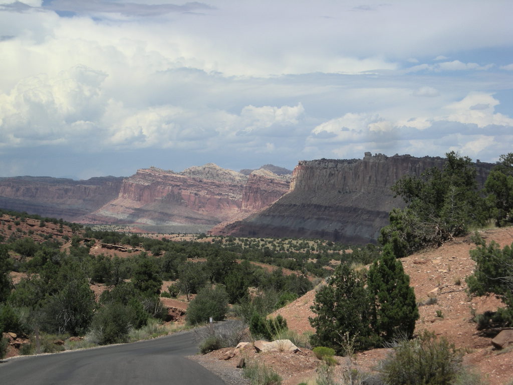
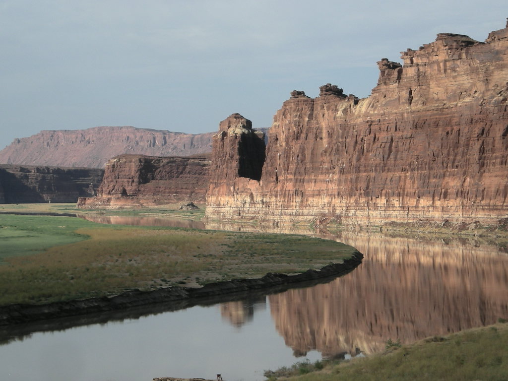
Sunday, July 27 was a really warm morning. We had a group of German girls who were touring the States camped next to us and three of the five slept under the stars out in the open. That’s the first time this trip we’ve seen that. They seemed to be having a great time. I know we were (and are!)We started off travelling west on UT 95 towards Hanksville. If you haven’t taken this route, we highly recommend it. It travels through some of the best scenery Utah has to offer and the road is superb with little traffic. I think we saw about 10 cars in 100 miles. That suits us! The crossing of the Colorado River is especially nice since you can view up and down river for some pretty nice pictures. Once in Hanksville, we gassed up and took UT 24 west straight into Capitol Reef National Park. UT 24 is also a pretty nice drive.
We arrived pretty early at Capitol Reef and the campground wasn’t very crowded. The best part of the campground was that it had plenty of tall shady trees! That’s what we’ve been looking for! The past two days had us pulling the picnic tables around and hiding in the shade till the sun either went behind a band of clouds or went down completely. It was pretty hot in the sun as anyone who has travelled the West in the summer can tell you. What a bargain this park is! It was only $10.00 a night and the wash houses were pretty nice as was the shade. Did I mention the shade?! After we settled in, we took the tour of the visitor’s center that explains the main geographical feature of Capitol Reef- the Waterpocket Fold that extends pretty much the length of the park (about 50 miles). Unfortunately for us, the only way to experience that feature is to travel a lot of dirt roads and the K1600GTL doesn’t really like dirt roads. Besides, rain was threatening and I a pretty sure the bike doesn’t fair well in mud! If you can’t get out to the Fold, take the one way 10 mile scenic road that passes some pretty nice cliffs and geological formations too. We did that but really weren’t satisfied because it seemed so short. So, after dinner we took a really nice hike that originated right at the campground. This trail takes you up for a pretty good view of Fruita, UT and the oasis that it is right along the Fremont River surrounded by the massive cliffs of the park. It really is an oasis. Once a thriving community with some pretty awesome orchards (still there), the last resident moved away and now the entire area is contained and part of the park.
There is going to be more great parks in store (if our plans work out) and the wrap-up of July, so stay tuned, we’ll be back soon with our next installment of our National Parks Tour! Greg & Cynthia.